Mt
MITSUTOUGE to get on the thicket. Half a day, (4
hours 16 minutes).
In March, (fine
weather).
Because it is here
in the middle of a pass way to extend to TENKA, the
tea dealer, the entrance of the mountain trail is
the approach which is almost the same as Mt MISAKA.
I arrived at the parking space of the entrance at
12:40, and prepared the change of clothes and the
preparation. The radio reported the maximum
temperature of KOUFU today by the weather in early
summer before and after 20 times.
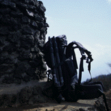
I began to walk at
13:00. I put the tripod for the pack of 40l of
MILLET which I bought yesterday, and put on long
spats, and had stick. Though neither spats nor
stick mattered, I decided myself to be handled why.
I can't pass through that if I don't attach the
chain because it is frozen though there is a way
which the car puts in the MITSUTOUGE direction as
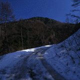
well from the place where I parked. It is decided
that I climb the roadway because the mountain
trails are the way and the combination, too. It is
tired because it doesn't seem to be mountain
climbing. Though I sometimes walked the inside of
the tire mark, it slid, and difficult, and the
shoes became dirty in the place to freeze the whole
surface in the place where the mud came out. There
was a sign of "from this, the prohibition of the
general car penetration" in the place where I
walked for about 30 minutes, and I thought "Was it
easy if I came in here?". I kept climbing it
without taking a rest because I was in good
condition and I didn't have the heartbeat and the
throat wasn't thirsty, either. When I do my best
and I am climbing it, I have the sound of the
engine from the top. Because the car approached
here and seemed to come, I moved by the side, and
the jeep which I wound the chain around when I was
waiting had come down. I go the person's of the
cottage beginning to buy it certainly. I kept
climbing it, and arrived at the divergence under
the hut at 14:07 with seeing the pattern of the
chain left on the snow.
I changed the
direction even if I took a rest because there was a
little observatory in its right hand. At that
moment, I slipped with the mud of the slope, and
pushed the slip. I walked with removing the dirt by
the snow of the circumference because the handle of
stick and my both hands were covered with mud. The
conviction can't have me after the short rest if it
is Mt KENASHI because there is no sign though I
went to Mt KENASHI and I had been returned. There
were few guideposts, too, and it was thought the
unkindness though I considered that the climbing
the mountain guest of the number came here very
much when I did from the bench which is here very
much, and the scale of the cottage. I began to walk
the way with the mud at 14:19, and passed through
the side of the FUJIMI villa at 14:45. Though the
villa seemed to be open, it put many things
indiscriminately without figure. It doesn't seem to
be a mountain to be what because it is the mountain
trail of about the summit of a mountain though it
can be carried because the jeep puts it
here.
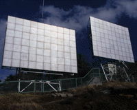
I arrived at the
summit of a mountain of Mt KAIUN at 14:55. I have
the sound of the machine though the electric wave
tower of NHK stands just by the side of the summit
of a mountain and the building is uninhabited.
Because the weather was good, I could see the
mountains of Mt FUJI and Kai well. I took the
summit of a mountain souvenir picture, and drank
the oolong tea, and took a rest. Though I couldn't
decide whether I was returned, I disliked walking
in the roadway of full of cottages and going down.
So, though I became a roundabout way a little, I
went to the SEIHACHI pass, and walked in the
roadway from there to my car, and decided to go
down. I don't meet with a disaster even if it gets
dark if it goes to the roadway. Though I began to
walk at 15:10, it became a slope to the peak which
the big electric wave tower is in soon. I was
disappointed because there was a sign nowhere
though I thought with Mt OSUTAKA. The oil of the
building smelled bad though I passed through the
mountain trail where it passed through the side of
the building of the electric wave tower.
It was the urgent
terrific slope though the way to the SEIHACHI pass
direction was descent. I go down carefully with
looking for the branch which me taking with the
step or the hand in the circumference because it
slides and falls when the snow which I stepped on
freezes. It is early, and the knee is easy, too,
because I gain the distance consequently though the
place where the snow is soft slides. But, I fell
down at last, and dealt a heavy blow to the right
knee. My right foot slid in the mud slope which the
left moved to. There was no hindrance in a walk
because the wrong point did seem that fortunately
be in the joint and the bone. The foot can't be put
imprudently because the mud on the surface slides
with the slope of the soil as well like a surface
avalanche. Only my right foot slid many times after
that as well, and decided that I intended to make
the title of today's diary "The right foot is
silly.". Because the right foot became a mountain
foot, it was thought the benefit that the bottom
outside the shoes hit the ground. As for the
mountain trail, the condition varies according to
the ice, the snow, the mud, the rock, and I must
change how to walk many times. I did my best even
if I walked without anyway taking a rest for one
hour. Sunlight to come in from the left is high,
and the sun is warm. The time seems that still be
fully. I took a rest because I stood up in the
little peak at 16:14. Though I drank the oolong tea and the jelly drink, it was not the mood that I
made the Chinese noodles. When I began to walk
again, the way became a bamboo grass wood, and
became the slope covered with dead leaves after
that. It sometimes slides though it seemed to be
snow that the dead leaves flowed on the shoes and
interesting. The bottom was full-scale ice when I
could try to get out of the way from the leaf. I
stood up in the peak whose it was higher than the
surrounding peak at 16:29. Though I thought with Mt
OHHATA, there were not a sign and a guidepost here,
either. I recorded the place in GPS, and walked
soon, and arrived under the steel tower of the high
pressure electric wire at 16:38. I was supposed to
go to the roadway if I hit col between Mt SEIHACHI
and Mt OHHATA and went down to the left along the
electric wire.
Though I put the
pack and I looked for the way, I could confirm the
way for a control like the lift of the skiing
ground. It was decided that I went down to the left
from here on the stock, the map because the roadway
from Mt SEIHACHI was long, too, after I looked up
at Mt SEIHACHI and I was. I thought that you were
allowed to turn back when it took the time and the
worst because the equipment such as a simple tent,
rainwear had the head lamp, too, though it was not
on the map. Though I began to walk at 16:44, it
stopped knowing the way soon, and it was walking in
the river which the water was not in when it was
considerate. I stopped, and there was a point which
was a way when I look around the right and left,
and climbed it there, and tried to walk in the way.
But, it sometimes stopped finding out the way many
times when I removed the route a little because the
ice and the snow slid. Since I still proceed for a
while, the way has gotten clear. After that, the
way became the perfect thicket which the thin
branch projected from the right and left to, and
the condition continued to it for a while. It
became the height above sea level that the tree of
the kind which I said so grew. Though the branch is
within eyes and it is troublesome, I shut my eyes,
and I can't walk. I put up stick 2 before the face
like the player of the descent in 10cm, and I had
myself, and divided the branch, and advanced. I had
to pass through the thicket in the place where the
thick branch hung down low with getting it on. I
jumped into the roadway suddenly at 17:02. The
place feels secure because I can reach my car at
last if I go this down to the left though it isn't
understood precisely. I drank the oolong tea, and
took a rest. Though I thought that the very long
time was made to walk the roadway, I began to walk,
and reached my car at 17:16 after eight minutes. I
met no one today except for the person of the jeep.
I could confirm only the old-fashioned footprint in
Mt SEIHACHI direction from Mt MITSUTOUGE, and there
was no footprint which got clear in the degree of
the beast distance in the descent from the steel
tower.
The trousers became
dirty in the mud because the shoes were very dirty
and I fell down though I used spats, too. Though I
thought the injury of the right knee only the
bruise, there was a cut in two places, and bleeding
spread out to the outside.
Mt
MITSUTOUGE
[Mt KAIUN=1785.2m] [Mt
OSUTAKA=1775.0m] [Mt
KENASHI=1732.0m]
|