

Transportations
getting there
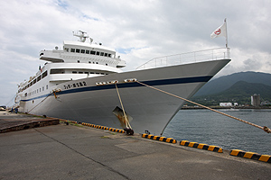
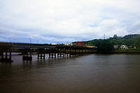
Yakushima is located 70 kilo meters off the Satamisaki peninsula which is south tip of the main land Kyusyu. A ferry Yakushima-2 for the Miyanoura port of the island daily departs at Kagoshima in the morning. And it becomes the return trip for Kagoshima in the afternoon.
Two companies have introduced high-speed boats (jet foils) on the seaway of Yakushima, Although these trip need over two hours and in some operation which destination changes Anbo known as second largest town of the island. A small airport lies on the northwest seaside of Yakushima, which connects to Kagoshima airport with several scheduled flights a day. Since Kagoshima airport has a role for a commuter hub that links Nansei (southwest) islands of Japan, relatively frequent flights are available from other main cities. But the airport is far from the center of Kagoshima city, Flying to Yakushima isn't always best choice when you reach the Kagoshima with not using the airline.
It must be better to select the seaway with convenient connection for the port, while you want to use other transportations such as Shinkansen for there.
 |
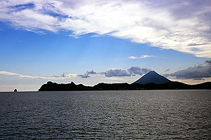 |
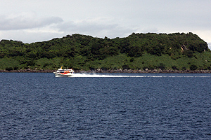
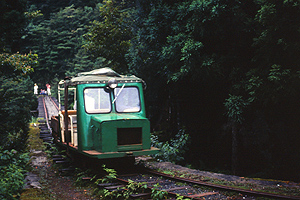
| Ferry Yakushima 2 which displacement is 3400ton has been in service from 1993. | Mt.Kaimondake positioned the entrance of the Kagoshima bay shows remarkable conic shape. |
 |
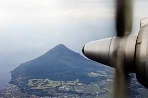 |
| A Jet foil operated by cosmo line is named Rocket although that is turbine propellant. see Cosmoline Another company operates Jet foils too. see Toppy | Mt.Kaimondake has seen under the plane.It needs 30 minutes for Yakushima with a turboprop airplane after taking off the Kagoshima airport.JAL |
 |
 |
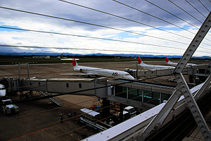
| Kagoshima airport. JAL has some flights for Yakushima, also has many domestic flights to Kagoshima. ANA and Skynet asia airways have the flights for Kagoshima. Nangokukotu operates bus service to the airport.See Kagoshima airport. | JR Kagoshima cyuoh eki(central station), At where Kyusyu Shinkansen has reached. In front of the station,there is a tramway (calls shiden) connects to Idurodori at the city central where is near the port. Be care about the name has cyuoh, Because another Kagoshima station is existed. Shiden |
Transportations in the island
A scheduled bus runs two third of the part of encircled road along the coastline hourly. There is no bus service from the northwest Nagata to southwest Ohkono-taki. Three lines of buses for inner mountain areas are operated in tourism season. But there is no frequent schedule. You should check the timetable for buses.
Mountaineering
The highest peak Miyanouradake and surrounded higher peaks are called Okudake which indicate hidden mountains. Actually, only the Nagata peak located southwest can be seen from the coastline. A trail runs longitudinally through the peaks. And several approaches for the hidden area are available. But two trails frequently walked show good conditions.
Yodogawaguchi course
A trail from Yodogawa-koya is most easy way to the summit area. Usually it takes four hours to the summit of Miyanouradake. The trailhead is at the side of Anbo-rindo(forest road) which
begins at Anbo that the second largest town of the island. You can reach the inner part of the island with well maintain road. After passing through the park Yakusugi-land, a massive cedar
Kigensugi stood at the side of the road. It became a well known sightseeing spot which can be visiting with a car. In tourism season, Scheduled bus goes up there. 
Get off at the last bus stop of Kigensugi. Walking one hour with a paved road is enough to reach the trailhead for Yodogawa-koya.
From there, one hour walking along a trail in woods is enough for the a hut Yodogawa-koya which is built beside the Yodogawa river.
At a green steel bridge over the river, the trail goes up to the summit area.
Another approach to the summit is to take the just opposite way.
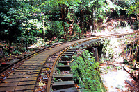
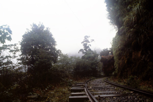
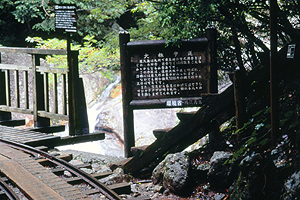
Fast half of the course follows on Okabu-hodo trail where crowded with sightseers for the oldest cedar Johmonsugi. Other several massive oldest cedars also stood beside the trail named Okabu-hodo which been on the northern slope of river Anbogawa. The course starts at the forest road Arakawa-rindo, which is a branch of the Anbo-rindo that used for going to the park Yakusugi-land and approaching the Yodogawaguchi trail. It takes two hours walking on the narrow gauge railway, which had laid for the forestry management.
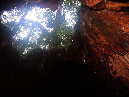
At the point of railway crossing a stream Ohsugidani(means big cedar valley). Okabu-hodo(means big stump trail) begins. Entering the trail goes up along the stream. You will meet first large cedar tree Okinasugi. Next, you debouch a space at where a big stump beside the trail. Taking a break for looking up. This stump was origin for the name of the trial. It is considered a big cedar tree had cut down 400 years ago and several cedars around stump have been growing to capture the sky. It has been told that forestry workers had been use the big stump for a shelter and in 1914 American botanist
Wilson has stayed inside of the stump. Therefore, the stump got a name Willson-kabu after his visiting.
From here, the trail becomes steeper and a small width boardwalk almost continues to the Johmonsugi. You need one hour for that.
An upright big cedar is appeared in the right side of the trail, which had known as the biggest cedar of Yakushima and got the name Daiohsugi (means king of cedar). However, bigger Johmonsugi has been found in 1966, and who succeeded his position.
Continue taking the ascent way, you must meet the large wooden deck enclosed the Johmonsugi.
To protecting roots of the oldest cedar tree, which was built when the Johmonsugi was becoming popular as a sightseeing spot.
If you'll be there on rush hour, you must encounter the jam up visitors.
There is the last destination of day hikers. After taking a picture for an evidence to visit the oldest tree, most of visitors are rushing to the way for home.
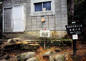
Proceeding less than 10 minutes with the ascending direction, you will meet a small shelter Takatuka-goya built at the branch of the trail Miyanoura-hodo which had come from Miyanoura directly. Unfortunately we can't use this route now because uncertain condition of the trail.
Anyway, name of the trail for the summit is changed Miyanoura-hodo for this reason.
Since the hut made with concrete blocks has only small capacity and a small stream isn't enough using water to cook,
You should progress to the next hut Shintakatuka-goya(newer Takatukagoya) with an hour climbing.
Starting from the Shintakatuka-goya, you need an hour climbing with a bumpy trail for the summit area. Along the course, Eye catching scenery of rocks and low height cedars appear as occasion. You have stepped in the core region of Okudake mountains, everything you met attracting you.
You will be passing over the forest limit and the trail goes through the banboo grass area. Then you are led a branch for Mt.Nagatadake. With taking the right, the second heighest peak Mt.Nagatadake is ahead.
Visiting Nagatadake is rare with the reason that it requires adding two hours roundtrip, although the peak is worth to stand.
Several granite peaks ride on the steep cliff around the river Nagata can be prospected from the northwest habit Nagata in fine day. The peak of Nagatadake is also included as one of them. Climbing a rock sit on the main peak of Nagatadake which gives you a bit difficulty for finding the route, However you may see the coast side Nagata at the direction of the river which starts just under you.
Going back to the branch for the Miyanouradake and climbing up the steeper slope, you will reach the summit of Mt.Miyanouradake soon.
If you bring your luck, you will enjoy the scenery from the summit of the island. Otherwise you will give up to be there with only seeing the post of height. In worst case, you will be beaten by stormy rain.
Anyway, you need to decide the way to the home. There are two options.
First one is just going down through the way you climbed up.
You can easily reach the bus stop that you started. And also you can change the way to Shiratani-Unsuikyo gorge at the Kusukawa-hodo branch. The trail goes up to Tuji-toge pass, then down to the park Shiratani-Unsuikyo where scheduled bus is available in tourism season. And a hut Shiratani-koya built beside the trail for the park is capable for staying the night. Only one thing you should mind is that trails in park Shiratani-Unsuikyo cross the streams and getting danger for swollen streams after rain days.
For alternation, Use the trail passing through the several peaks of Okudake area, You will down the hut Yodogawa-goya. Leaving from the summit with taking the way to south, You will see rocks sitting on the peak Kuriodake just after to down the steeper trail of the Miyanouradake peak. Inside the rocks a small space is existed, which must be used as an escape shelter for the stormy rain.
The trail doesn't ascend the peaks for Okudake from here. Each summit shows a trace but it is seen as the rare using, although the last peak Kuromidake been in the right side of the trail has a fixed route for the summit as an exception.
At the Nageshidaira where flat rock provides a space for the break, the trail downs to the marsh. After passing through the branch of Kuromidake, you will be in the Hananoego marsh. From on a boardwalk which crossing the marsh, Trail for Yodogawa-goya begins. Be care about that another route to Ishizuka-goya branches at there. And also after walking through the marsh to opposite hand, there is another route continued. Both are less common for the tourist, you should care about correctly seeking out the trailhead of Yodogawa-goya.
Less than 10 minutes walk, you will meet the next small marsh named Ko-Hananoego and then trail leads in the forest. From there running down along trodden route, you will surely reach the green painted bridge
which crossing the Yodogawa river in front of the hut.
You should prepare at least tow hours for Kigensugi bus stop. When you have not enough time for the last bus, you should stay over night here. About 40 minutes walking, eventually you will be closed to the road which paved. There is the trailhead of the Yodogawa route. Turning to the left here, and down with the road to the Kigensugi.
A trail continues to the Onoaida onsen started from the other side of the road. But I think it's better to avoid following the trail especially in rain day, because this route will cross the river.
You can know much about the course with the latter part of my description of Arakawaguchi course.
Arakawaguchi course
 The course is going up along the south riverside. Then you will meet a steel bridge crossing the river. Just after to over the river, Traces of Kosugidani village that had opened for a base of forest operation and closed on 1974 will be found. Keep going with the rail.
The Kusukawa trail comes from the park Shiratani-unsuikyo is joined. Almost one hour must be spent to reach here. Walking through the flat boardwalk attached on the railway tie is easier but more hour approach is remained for the trailhead of the Okabu-hodo.
The course is going up along the south riverside. Then you will meet a steel bridge crossing the river. Just after to over the river, Traces of Kosugidani village that had opened for a base of forest operation and closed on 1974 will be found. Keep going with the rail.
The Kusukawa trail comes from the park Shiratani-unsuikyo is joined. Almost one hour must be spent to reach here. Walking through the flat boardwalk attached on the railway tie is easier but more hour approach is remained for the trailhead of the Okabu-hodo.
Day 2
 |
 |
| The course runs on the railway laid for forestry. | A steel bridge crossing the river Anbogawa. When I visited, there are no facilities for visitors safe without a narrow wooden board. |
 |
 |
| The trailhead of the Okabu-hodo. | Entering inside the big stump called Willson-kabu is permitted. |
 |
 |
| Takatukagoya shelter:It had built for a escape shelter of Miyanoura-hodo.But hikers for Johmonsugi frequently use the hut for overnight stay.It must be busy on tourism season. | A globate rock appers. |
Sightseeing
A part of Yakushima was registered the world heritage list in 1993. The range designated is spreading from the central mountain area to the granitic west cast. This occasion happened that conserving the nature of Yakushima was recognized for all Japanese, although the name Yakushima got the top brand of conserved nature.
It must be the timing of change for tourisms of the island. Yakushima should take a direction of eco tourisms with that well controlled tourism gives certify for the sustained development of the island. But only the number of sightseers has been increased from that time. A large capacity ferry has been in operation at the same year of register, which carries tourist coaches to the islands.
High-speed boats made a revolution for the schedule of island tourism. Usually, sightseers arrive the island in the late morning using them. Then coaches hired by package tour companies run through the island rapidly linking several sightseeing spots with short intermissions giving the time taking a picture. The case of most short stay visitors must go off in the evening to stay in Kagoshima for next destinations. Now, Yakushima has been included the list of destinations for Japanese style island tourism.
Johmonsugi cedar
Johmonsugi has been believed as the biggest tree of Yakusima. The massive cedar tree who has sixteen meters around the trunk. The name derives from the prehistoric Johmon era known with the cord marked pottery and had been ended over two thousands ago. At when the tree had started his life. The age of Johomonsugi had been estimated as 7200 years old with the average growth speed of Yakushima cedar trees. But true age has been the controversial subject till now. One reason of that is there is no direct measurement from the growth ring since the stem of the tree is hollowed. At least the estimation of over 2000 years is widely accepted, although it's may be little difficult to say with relation to the Johmon era while most youngest case will be valid.
If you want to visit here at least 10 hours need to hike. See the mountaineering part of this page and also see the mountaineering page of mine.
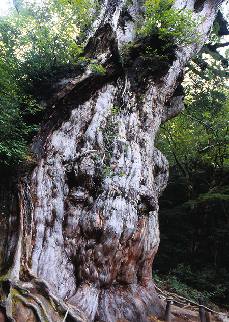 |
This picture was taken over 10 years ago.After that, A large wooden deck which keeping visitor away from the tree was built with purpose of protecting the roots. We cann't touch the bark of the tree now. |
Granite rocks
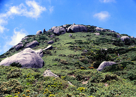
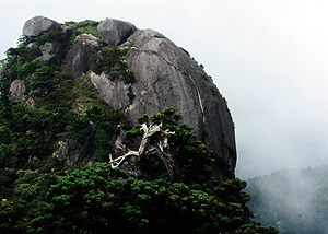
The granite rocks give the remarkable features to the mountain area of Yakushima. However, that is in some lower areas such as Mt.Mocchomdake gives the eye caching scenery.
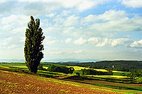
Nagata is the distant residential area located north west of the island. A mountain called Kuniwaridake is sits on six kilometers south from Nagata. The west slope of the mountain, which covered with untouched evergreen broadleaf forests and stretched to the waterline of coast is a part of the registered area of the world heritage list.
The shoreline of the west coast is worth visiting to see exposed granite rocks. The Yakushima lighthouse located on the north tip of the coast may give the best viewpoint around there.
Kagoshima prefecture has planed to extend the road to complete the circular road. I think some of reason was related to that forest road didn't have the capacity for heavy vehicles such as buses. But after some controversial opinions for the plan, road was hold the original width.
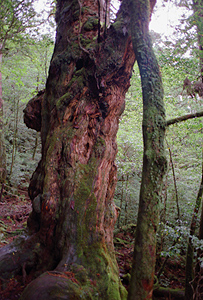
The woods made from the tree has grown in the stark environments shows eye filling dense growth rings, which use for making the high priced furniture. And these include much resin inside is also good feature for making durable wood products. Yakushima cedar (yakusugi) has both properties, was the most valuable products of the island in the past.
In Yakushima, It is a tradition told that only cedars which older than thousand years was called Yakusugi. Of course there is no difference with comparing the trees which age is under thousand years from the aspect of biological view. But people in Yakushima had been care about distinction with thousand years aspect of island.
Now, there is agreement for preservating own enviroment of the island, and that became the common thinking of most Japanese. It has been inhibited the forestry activities for producing Yakusugi materials, and it has been stopped.
Although, we need to imagine that many Yakusugi trees must be lost until that time. With the pessimistic point of view, we can tell that the only unusable trees are remained now. You must see Yakusugi trees with minding the Yakusugi forest is not a pure natural condition.
Some oldest Yakusugi trees stood near the trails have been known. But Unfortunately, we have no chance to see them since the difficulty for entering the deep forest area they stood.
With considering the preservation of forest, it is good that these trees will not change to the tourism resources forever.
But Visitors Yakusima must want to see some of them. There are some exceptions such as Okabu-hodo trails can be reached with day hiking.
For sightseers not to want approaching them, two parks provided seeing the Yakusugi cedar in the forest. One of which is park Shiratani-Unsuikyo located one of the gorge developed upstream of the river Miyanoura and can be approached from Miyanoura by using a car. A representative of the park is 3000 years old Yayoisugi stood at the 700m sealevel.
Another park named Yakusugi-land is located on the large stream of Anbo river,
It is approached with the Anbo forest road, which had made for forestry operation on the inner areas, however this role has ended and changes the road for tourism.
From Anbo where located eastside of the island, the road running up to the Odate pass which road is biforked. Take the left main branch, soon reaches the entrance of the park.
There are four paths in the park. Each of which differentiated by course time from 30 minutes to 4 hours. You should take the longest path, which may need four hours. You can meet the several over 1000 years old Yakusugi
cedars scattered in the forest.
Scheduled bus services to Yakusugi land or Shiratani Unsuikyo are available in tourism season from the Miyanoura port, however only small number of operations for each destination will run. You need to check the time table before planning to go there. And you must know both park will ask a small admission fee (Denotation for management is written) for entering.
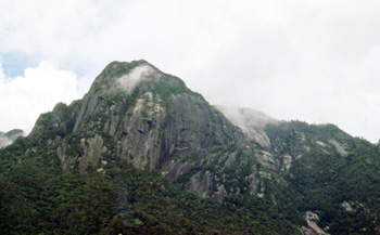
The eye catching summit Mt.Mocchomu dake sit on the south east part of the island, which can be viewed from even on the road.
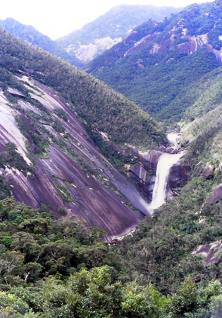
Senpiro no taki is a waterfall which located south east part of the island. And there is the place I recommend to visit since the well polished granite slope
is much amazed. 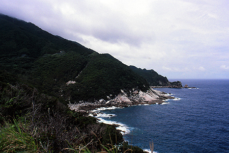
The cape Nagata-misaki is a good view point of the costline,in which white painted lighthouse stood with
a road going there. Cedars


|
||||||||||||||||||||||


mountaineering tools